4. Python工具箱具体样例代码(DEM流域分析-河网等级矢量化)
1.前提
如果你想自己写Python工具箱,那么假定你已经会ArcPy,如果只是自己用,完全没有必要,直接脚本运行。如果是给其他人用,为了简洁明了,适用这里。Python工具箱10.2无法加密,但是工具箱+Script脚本是可以加密的。10.5以上Python工具箱可加密。
本文只介绍Python工具箱,对于工具箱+Script脚本不是特别推荐!
2.需要了解的资料
Python工具箱需要知道哪些内容?
[1]Python工具箱 代码模板 (可自己新建Python工具箱 编辑查看代码)
[2]Arcpy.Parameter (重要*****)
[3]Python工具箱 输入参数类型(data_type) (重要*****)
[5]定义 Python 工具箱中的参数 (重要*****)
3.Python工具箱制作教程
[1]新建python工具箱
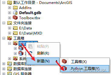
[2]右击 新建的Python工具箱 编辑
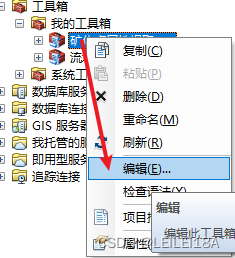
[3] 随后txt打开了代码,复制所有代码到py文件中,我这里用的vscode连接arcgis python2.7 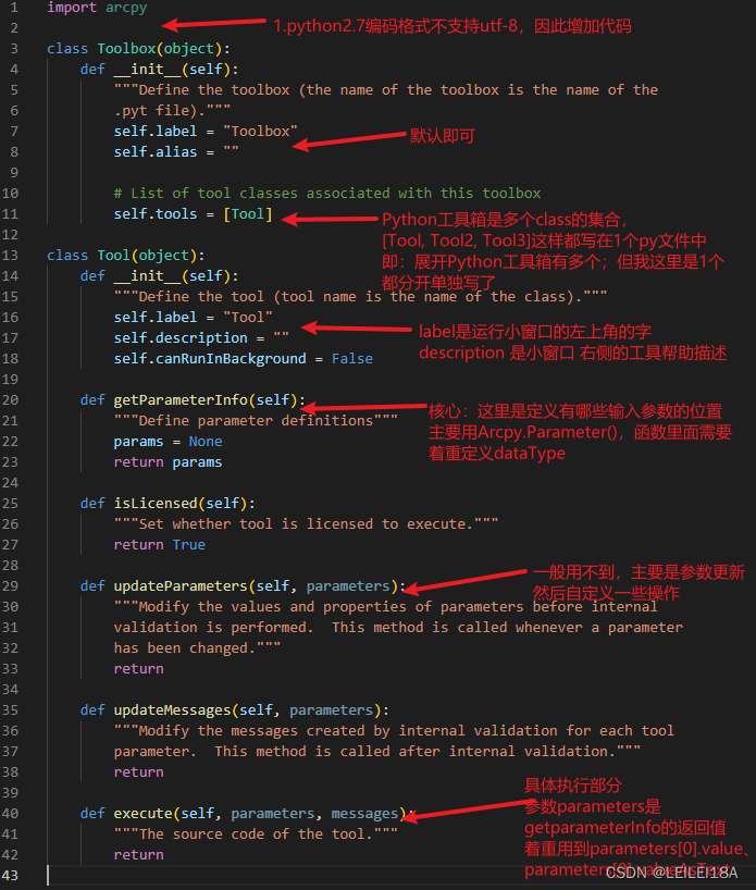
如上图所示,Python工具箱模板。需要关注的有上述箭头部分。
[4]待代码写完后,将代码复制到 “编辑” 的Python工具箱,然后另存为,选择编码格式“ANSI”,替换!
———————————————————————————————————-
小细节:
①Python工具箱不好调试,print无法输出信息,一般采用arcpy.AddMessage、arcpy.AddError输出信息;
②然后parameters[0].value .valueAsText这些都是arcpy.parameter的属性,查看我提供的Parameter官网介绍即可。
③注意中文格式,设置utf-8,另存ANSI格式。
④着重看给的 资料链接 [2]、[3]、[5] 官网说的很明白(中英文可切换),再结合我的样例代码,就很快理解了!
———————————————————————————————————-
4. Python工具箱具体样例代码(DEM流域分析-河网等级矢量化)
# 设置中文环境 对于中文字符串 前面加u  打印时 需要在字符串后加 .decode('utf-8')
import sys
defalutencoding = 'utf-8'
if sys.getdefaultencoding() != defalutencoding:
    reload(sys)
    sys.setdefaultencoding(defalutencoding)

import os
import arcpy
from arcpy import env
from arcpy.sa import *  #arcpy栅格计算的基本计算器,高级复杂的在arcpy.gp中

# 定义函数
def check_exists_and_delete(dataset_name):
    # 前提已经设置了env.workspace, 检测存在即删除
    if arcpy.Exists(dataset_name):
        arcpy.Delete_management(dataset_name)
        print(u'已删除:'+str(dataset_name))
        return
    return

class Toolbox(object):
    def __init__(self):
        """Define the toolbox (the name of the toolbox is the name of the
        .pyt file)."""
        self.label = "Python工具箱-流域分析"
        self.alias = "Python工具箱-流域分析"
        # List of tool classes associated with this toolbox
        self.tools = [Tool]
class Tool(object):
    def __init__(self):
        """Define the tool (tool name is the name of the class)."""
        self.label = "流域分析"
        self.description = "流域分析要求数据在gdb中操作!只需导入DEM,即可完成填洼-流向-流量-河网-河网分级-分级矢量化。依次生成的结果名称为输入DEM名称+_填洼"
        self.canRunInBackground = False

    def getParameterInfo(self):
        """Define parameter definitions"""
        param_gdb = arcpy.Parameter(
            displayName = "请输入工作空间(GDB):",
            name = "in_workspace",
            datatype = "DEWorkspace",
            parameterType = "Required",
            direction="Input"
        )
        param_gdb.value = env.workspace

        param_dem = arcpy.Parameter(
            displayName="请输入或选择DEM图层:",
            name="in_dem",
            datatype="GPRasterLayer", # , "DERasterDataset", "GPRasterDataLayer"
            parameterType="Required",
            direction="Input",
        )

        param_threshold = arcpy.Parameter(
            displayName="请输入河网分级整型阈值(大于):",
            name="in_threshold",
            datatype="GPLong",
            parameterType="Required",
            direction="Input",
        )
        param_threshold.value = 1000

        params = [param_gdb, param_dem, param_threshold]
        return params

    def isLicensed(self):
        """Set whether tool is licensed to execute."""
        return True

    def updateParameters(self, parameters):
        """Modify the values and properties of parameters before internal
        validation is performed.  This method is called whenever a parameter
        has been changed."""
        return

    def updateMessages(self, parameters):

        """Modify the messages created by internal validation for each tool
        parameter.  This method is called after internal validation."""
        return

    def execute(self, parameters, messages):
        arcpy.CheckOutExtension("Spatial")  # 必须执行,否则默认不打开??
        env.workspace = parameters[0].valueAsText
        # 相关操作在 系统工具箱->Spatial Analyst Tools->水文分析or地图代数
        # 2.DEM填洼
        DEM_Name = os.path.basename(parameters[1].valueAsText)            # 3-需要修改成自己的DEM名称
        arcpy.AddMessage(u"正在处理DEM图层:" + DEM_Name)
        DEM_TianWa_Name = DEM_Name + u"_填洼"                             # 注意 不能有- 可以是_
        outFill = Fill(DEM_Name)
        check_exists_and_delete(DEM_TianWa_Name)
        outFill.save(DEM_TianWa_Name)
        print(u"完成填洼".decode('utf-8'))
        arcpy.AddMessage(u"完成填洼")

        # 3.DEM流向  根据填洼结果 来计算
        DEM_LiuXiang_Name = DEM_Name + u"_流向"
        outFlowDirection = FlowDirection(DEM_TianWa_Name)
        check_exists_and_delete(DEM_LiuXiang_Name)
        outFlowDirection.save(DEM_LiuXiang_Name)
        print(u"完成流向".decode('utf-8'))
        arcpy.AddMessage(u"完成流向")

        # 4.DEM流量 根据流向结果 来计算
        DEM_LiuLiang_Name = DEM_Name + u"_流量"
        outFlowAccumulation = FlowAccumulation(DEM_LiuXiang_Name)
        check_exists_and_delete(DEM_LiuLiang_Name)
        outFlowAccumulation.save(DEM_LiuLiang_Name)
        print(u"完成流量".decode('utf-8'))
        arcpy.AddMessage(u"完成流量")

        # 5.DEM河网 根据流量 来计算  (arcpy脚本不允许使用RasterCalculator)
        DEM_HeWang_Name = DEM_Name + u"_河网"
        threshold = parameters[2].value                                                  # 4-需要修改成自己的流量阈值
        raster = DEM_LiuLiang_Name
        out_A_Calculator = Con(Raster(raster) > threshold, 1)
        check_exists_and_delete(DEM_HeWang_Name)
        out_A_Calculator.save(DEM_HeWang_Name)
        print(u"完成河网".decode('utf-8'))
        arcpy.AddMessage(u"完成河网")

        # 6.DEM河网分级 根据河网 流向结果 来计算
        DEM_HeWang_FenJi_Name = DEM_Name + u"_河网分级"
        outStreamOrder = StreamOrder(DEM_HeWang_Name, DEM_LiuXiang_Name, "STRAHLER") # STRAHLER分级方法 更合适
        check_exists_and_delete(DEM_HeWang_FenJi_Name)
        outStreamOrder.save(DEM_HeWang_FenJi_Name)
        print(u"完成河网分级".decode('utf-8'))
        arcpy.AddMessage(u"完成河网分级")

        # 6.1 DEM河网分级后栅格结果  矢量化
        DEM_HeWang_FenJi_SHP_Name = DEM_Name + u"_河网分级矢量"
        check_exists_and_delete(DEM_HeWang_FenJi_SHP_Name)
        StreamToFeature(DEM_HeWang_FenJi_Name, DEM_LiuXiang_Name, DEM_HeWang_FenJi_SHP_Name, "NO_SIMPLIFY")
        print(u"完成河网分级矢量化".decode('utf-8'))
        arcpy.AddMessage(u"完成河网分级矢量化")

return原文地址:https://blog.csdn.net/LEILEI18A/article/details/134636995
本文来自互联网用户投稿,该文观点仅代表作者本人,不代表本站立场。本站仅提供信息存储空间服务,不拥有所有权,不承担相关法律责任。
如若转载,请注明出处:http://www.7code.cn/show_1074.html
如若内容造成侵权/违法违规/事实不符,请联系代码007邮箱:suwngjj01@126.com进行投诉反馈,一经查实,立即删除!